

Hey there, fellow adventurer—if you're searching for "Yosemite rock fissure", you're probably curious about the massive crack stretching across a granite cliff in Yosemite National Park. This dramatic fissure is not just any crack; it's a newly-formed rock fracture near Glacier Point, capturing attention for its potential to send a huge slab of rock crashing into Yosemite Valley, California. This phenomenon highlights the constant rockfall hazards in this breathtaking park, where steep cliffs and natural exfoliation joints make rockfalls a genuine risk for visitors exploring below.
Yosemite rock fissure: what this keyword is actually referring to
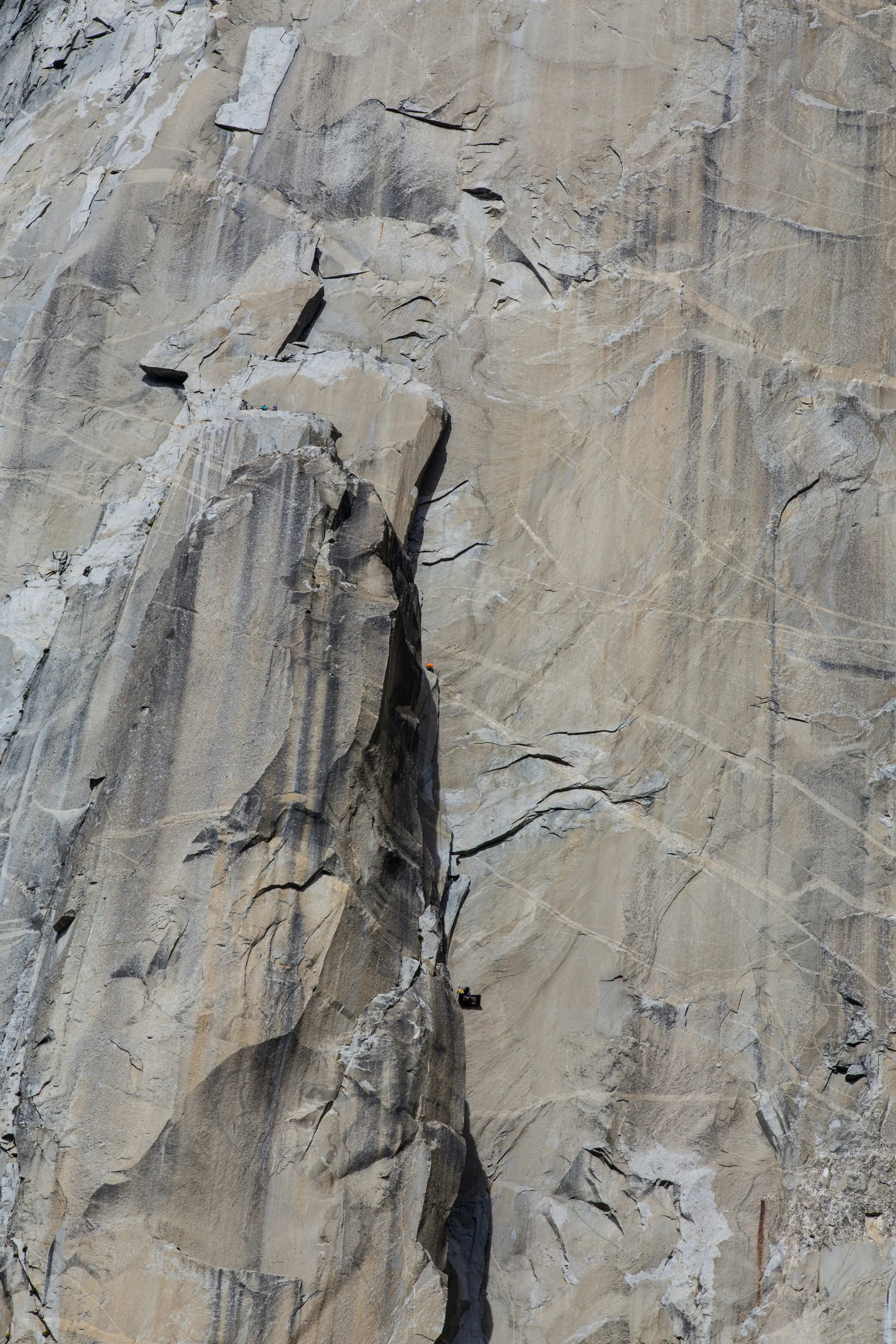
Picture this, reader: the "Yosemite rock fissure" buzz refers specifically to a dramatic, rapidly widening crack—nicknamed "Super Natural"—on the western side of the iconic Royal Arches cliff in Yosemite Valley. First spotted by climbers in 2023 as just an inch wide, it has now expanded to about four inches. Some reports even describe it as stretching up to 200 feet long and four feet deep, partially detaching a massive granite pillar. The fissure has sparked active cracking sounds that left even a 15-year veteran park geologist stunned.
The fissure gained widespread attention when Yosemite National Park swiftly closed key climbing routes such as Super Slide, Serenity Crack/Sons of Yesterday, Peruvian Flake West, and Rhombus Wall. These measures were taken to avert a potential rockfall disaster, highlighting the urgency of addressing this unstable feature. This event is a stark reminder of Yosemite's history, which has seen over 1,000 rockfall incidents in the past 150 years.
Where it is in Yosemite Valley and why it matters
Royal Arches context: a major cliff with high visitor and climbing traffic
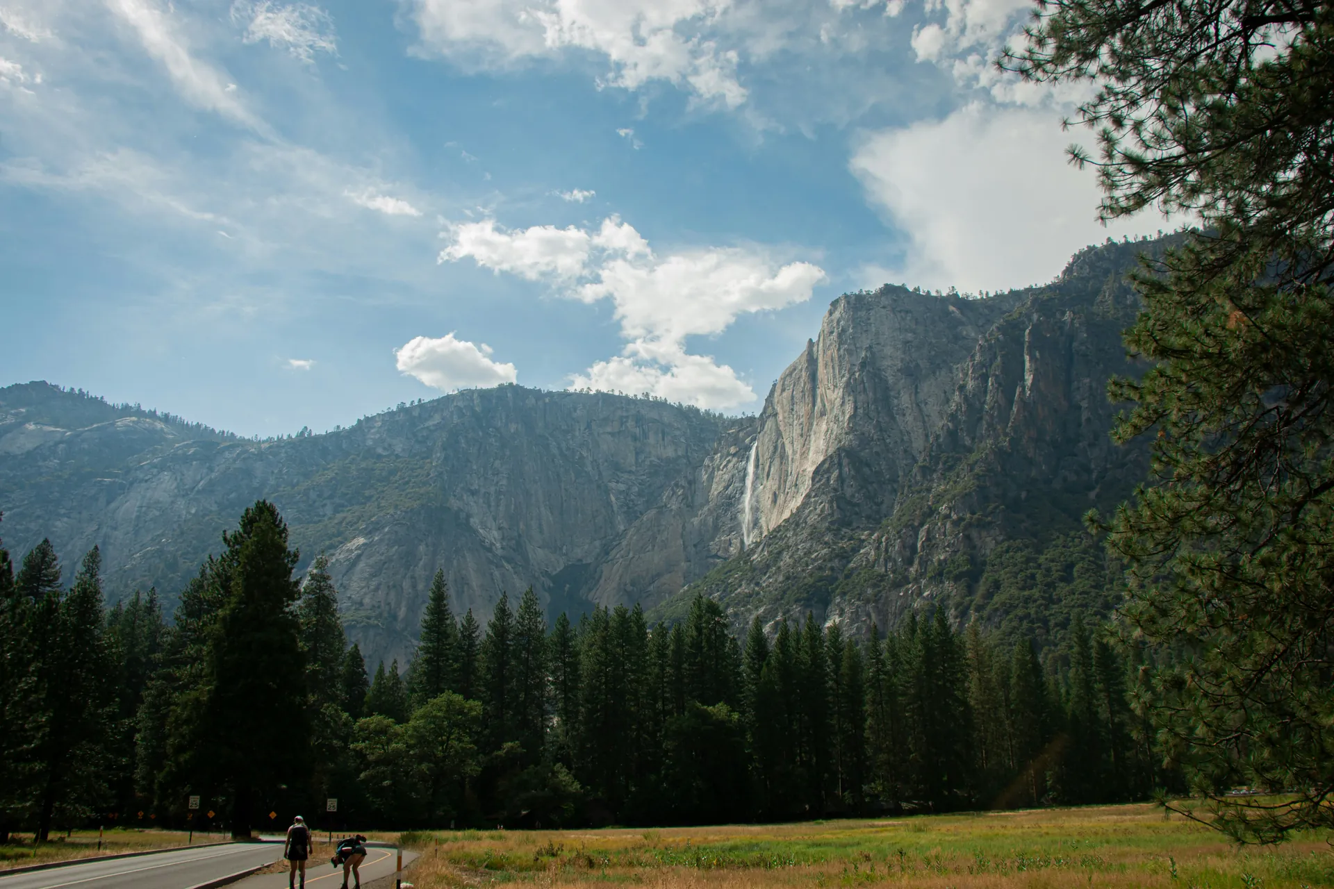
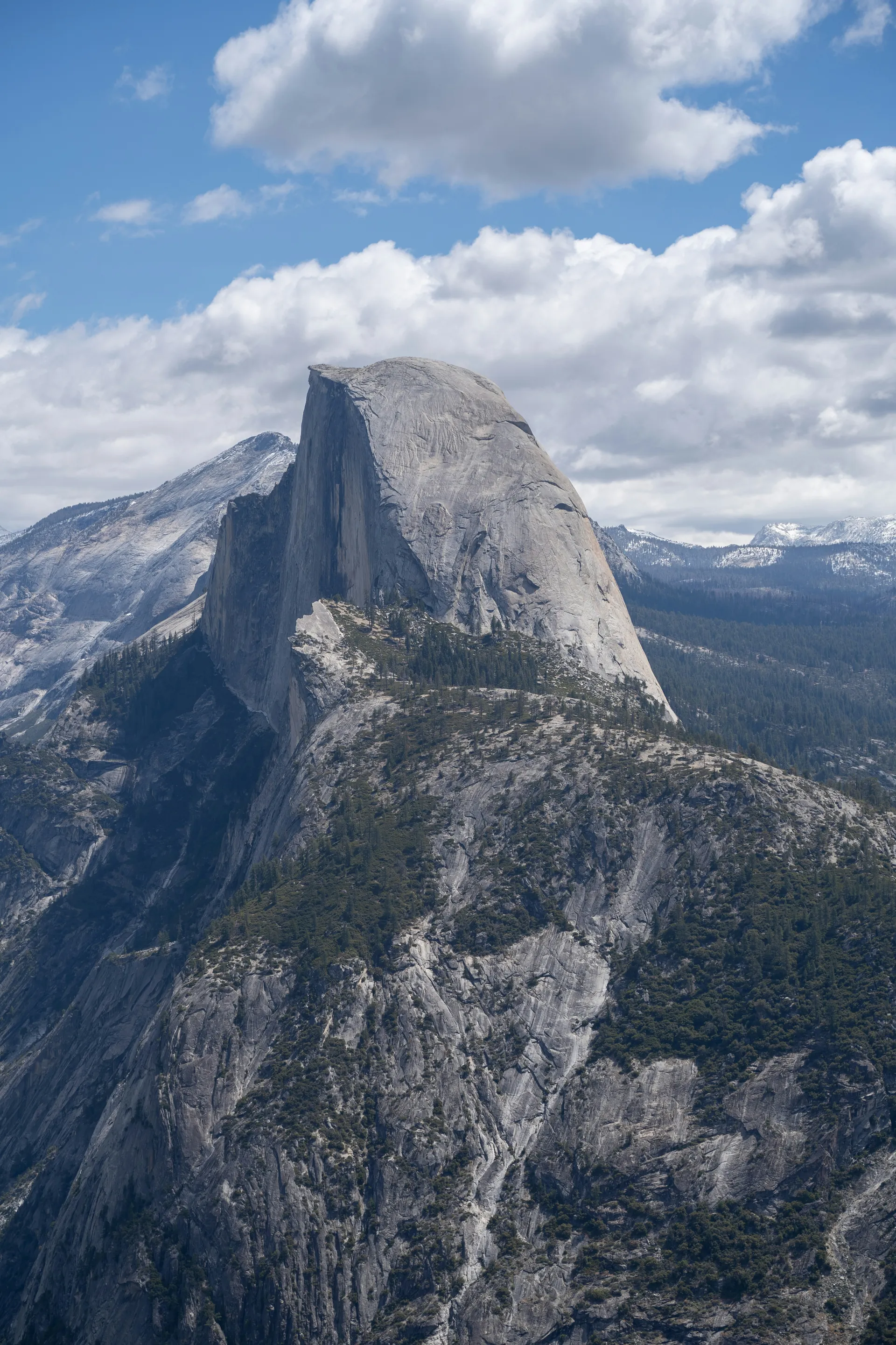
This fissure is located high on the north wall of Yosemite Valley, right on the Royal Arches—a breathtaking cliff known for its concentric granite exfoliation arches. It sits opposite Glacier Point and near the seasonal Royal Arch Cascade waterfall, attracting many visitors from the nearby Ahwahnee Hotel area. As a Yosemite classic, Royal Arches experiences heavy climbing traffic, featuring popular routes graded from 5.7 A0 to 5.10b. Notable among these is the iconic 16-pitch Royal Arches route, which serves as a prime destination for both novice and experienced climbers seeking to test their skills high above the valley floor. If you’re planning to challenge yourself here, consider reviewing our training for climbing guide.
Why proximity to routes, approach areas, and travel corridors changes risk exposure
Its position overlooking key approach trails from the Ahwahnee parking lot, belay ledges, and descent paths such as the Royal Arches Rappel Route or North Dome Trail significantly increases risk exposure. This location places climbers, hikers, and even casual visitors directly beneath a potential fall zone. The high-traffic nature of this area turns a geological curiosity into an urgent safety concern, as any rockfall could send massive debris toward the frequently used travel corridors below.
What happened: from “new crack” to “unstable rock”
How a new fissure is typically identified and assessed in a park setting
In Yosemite National Park, vigilant climbers are often the first to notice anomalies such as cracks or fissures. For example, the Royal Arches fissure identified in August 2023 sparked immediate action. Park geologists conduct ground inspections, utilize drone surveys, and employ tools like crackmeters to measure daily shifts caused by thermal expansion and contraction. Experts, including Greg Stock, monitor these fissures in real-time, listening for sounds of cracking or signs of accelerated growth. They combine on-site data with historical records of over 1,000 documented rockfalls to assess urgency, although full certainty is rarely achievable at the outset.
What “detached” or “unstable pillar” means in practical risk terms
When officials describe a formation as a "detached pillar," it means the base of the rock slab has fractured significantly. These fractures, caused by exfoliation or sheeting joints, weaken the structure to the point where gravity and natural rock movements could lead to a sudden collapse. Such an event could release thousands of tons of rock unpredictably down steep terrain. The inherent uncertainty of these assessments stems from hidden internal stresses within the rock, which makes exact predictions impossible. This is why park officials prioritize proactive closures to ensure safety rather than waiting for a potential failure.
Why granite cliffs crack in Yosemite
Exfoliation and stress release: the big-picture mechanism
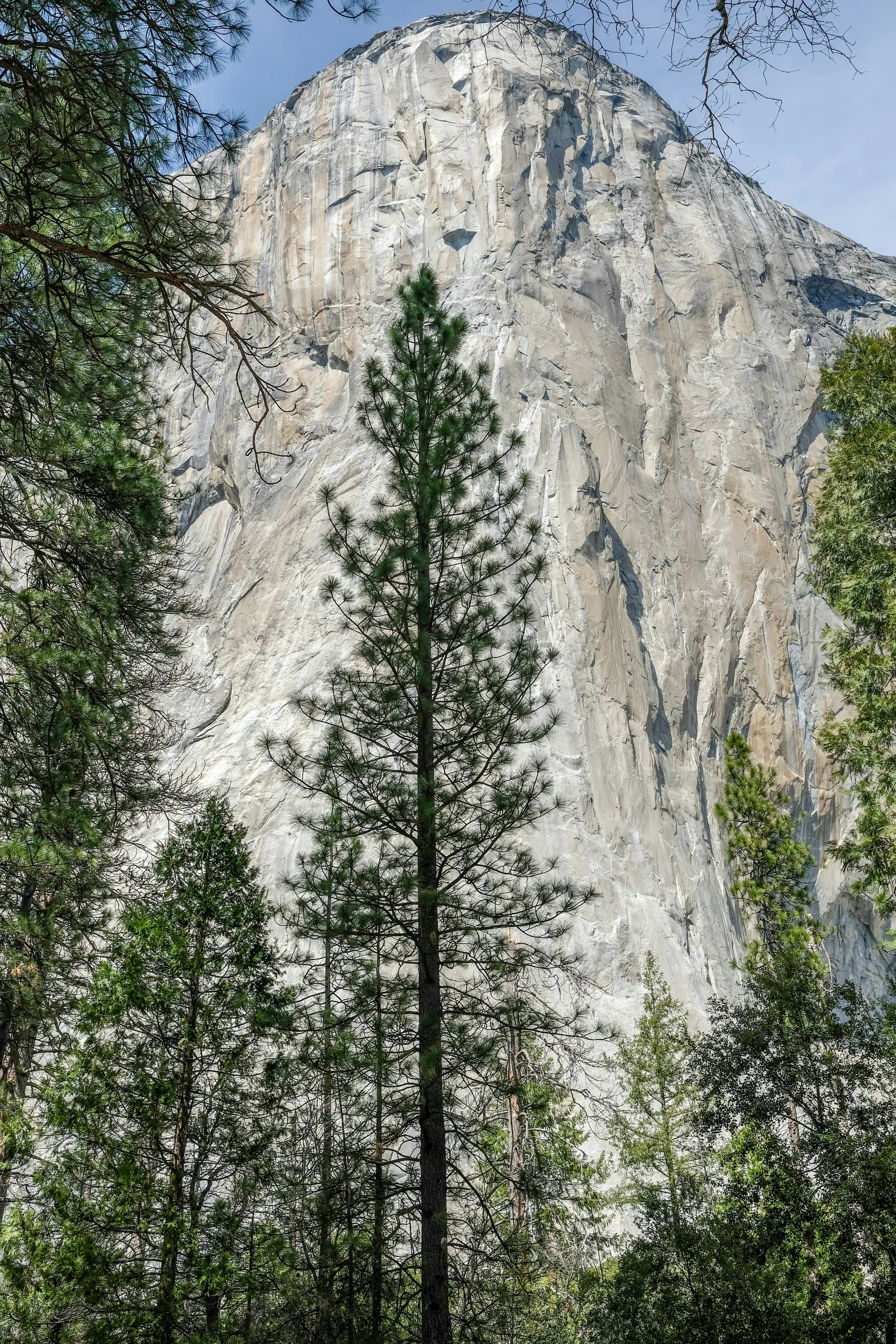
Reader, Yosemite's granite cliffs, crafted deep underground as intrusive plutons millions of years ago, crack primarily through exfoliation—a process where massive slabs peel away like onion skins along curved joints parallel to the surface. As overlying rock erodes away over eons, the reduced pressure allows the granite to expand outward, forming exfoliation sheets that can reach hundreds of feet thick. These sheets eventually spall off, sculpting iconic domes like Half Dome.
Weather and water: how temperature swings and moisture can contribute
Daily temperature swings in Yosemite Valley cause the surface to expand up to an inch, widening pre-existing joints. Freeze-thaw cycles push water into cracks, freezing and prying them apart further. Additionally, heavy rain builds hydraulic pressure within these fissures, accelerating detachment. Vegetation roots and chemical weathering along these planes further weaken the rock, transforming slow geological changes into dynamic hazards.
Rockfall as an ongoing natural process in Yosemite
These cracks and falls are not anomalies but part of Yosemite's natural evolution. Approximately 60 rockfalls occur in the valley annually. Major events, like Half Dome's 2010 shed of 2,300 metric tons, reshape cliffs and expose fresh rock beneath. This is a vivid reminder that the park's landscape is actively sculpted by this relentless cycle.
What closures mean for climbers and visitors
How closures are defined: boundaries, routes, and affected zones
These closures legally encompass specific boundaries on the Royal Arches north wall. Access is strictly prohibited to routes from Peruvian Flake West through Serenity Crack, Super Slide, and Rhombus Wall. This includes approaches, belay areas, and any descent paths within the hazard zone as defined by park orders under 36 CFR Section 1.5(a). The affected zones also extend to ground-level trails and picnic spots directly beneath the climbing areas. Enforcement is carried out through signage, ranger patrols, and real-time updates available on the NPS closures page, ensuring everyone is shielded from potential overhead dangers.
Why “closed” is not just a recommendation
These closures are not merely suggestions but are enforceable Superintendent's Orders. Violations can result in fines of up to $5,000 and even jail time. The rules are based on federal regulations designed to protect lives from the unpredictable risk of pillar failure. Past rockfalls have tragically caused injuries and fatalities, proving that compliance is essential to prevent further incidents. Following these closures also allows for ongoing monitoring, which could lead to the safe reopening of affected areas in the future. Ignoring these orders not only puts your safety at risk but also endangers rescuers and could lead to serious legal consequences. Always check official NPS sources before planning your visit.
What hikers and non-climbers should know
Why a climbing hazard can affect non-climbers nearby
Even if you're not a climber, rockfall dangers can still affect you. Rockfall from Royal Arches poses a serious threat to hikers on approach trails, picnickers relaxing in talus zones, and even casual strollers passing through the valley below. Tumbling boulders do not discriminate between climbers and non-climbers. The large detached pillar above these popular travel areas serves as a stark reminder that gravity doesn't respect skill levels. A massive slab falling 1,500 feet can reach lethal speeds, whether you're roped in for climbing or simply taking photos.
Why "warning signs" are not reliable go/no-go indicators
Although park rangers post signs and close off areas proactively, it's important to understand that rockfalls in Yosemite Valley occur approximately once a week, often without any warning. These events can strike unpredictably, even in zones considered "safer." Posted caution signs are helpful but should not give you a false sense of security. Areas outside of official closures are not completely risk-free either, as rockfalls can extend beyond mapped danger zones.
To stay safe, always maintain a safe distance from cliff bases, avoid camping under granite faces, and strictly adhere to closure orders. This is your best defense against rockfall, which is the leading cause of injuries and fatalities in Yosemite. Remember, the unpredictable nature of this hazard makes vigilance and caution essential for everyone visiting the park.
How Yosemite manages rockfall risk over time
Temporary closures as risk reduction
Temporary closures act as Yosemite's primary defense, swiftly evacuating visitors from danger zones and significantly reducing exposure by 95%. Strategic relocations, such as those implemented at the former Curry Village (now Half Dome Village), have been key. High-risk tents and buildings were dismantled following the 1999 and 2008 rockfalls, ensuring safety in these areas. This proactive approach, guided by hazard maps supported by the USGS, has successfully prevented injuries by keeping visitors away from talus and boulder runout zones. This allows natural processes to occur without the risk of human interference.
Monitoring and reassessment: why timelines are uncertain
Park geologists use advanced tools like high-resolution drones, laser scanning, crackmeters, and cosmic ray exposure dating to monitor fracture propagation and simulate potential rockfall trajectories. They reassess conditions weekly or after specific events to decide whether to extend closures or reopen areas. However, timelines remain unpredictable due to unexpected triggers such as hidden seismic activity or sudden pressure buildup. While computer models help predict high-risk zones, they cannot pinpoint exact timing. As a result, updates are continually adjusted based on new data, ensuring a balance between visitor safety and access. For instance, post-rockfall trail clearances often require blasting and weeks of debris removal before reopening.
Stewardship and Community Responsibility
Respecting Closures: How It Protects People and Long-Term Access
When you honor a closure at Royal Arches or anywhere in Yosemite National Park, you're not just following rules—you're actively safeguarding lives and ensuring future access for everyone. Every enforced closure provides valuable data that parks use to refine hazard zones. When visitors comply, rangers can focus on monitoring conditions instead of conducting rescues, and park officials gain the confidence to reopen areas once conditions improve.
On the other hand, crossing boundaries leads to incidents that often result in longer and broader closures. This diverts resources away from education and stewardship. By respecting signs and closures, you directly contribute to the park's ability to safely serve more people over time.
Reporting Observations Responsibly (When and How, at a High Level)
If you notice fresh cracking sounds, rockfall debris on trails, or unstable-looking boulder fields—especially near Yosemite Valley's talus zones—it's essential to alert a ranger or use the NPS website feedback channels. Avoid investigating these hazards yourself or posting unverified alerts on social media. Climbers who spot new fissures, such as the one at Royal Arches, play an important early-warning role. For example, in 2023, an observer who reported "Super Natural" helped park staff take timely action.
Your factual and timely report to park officials (rather than speculation online) can kickstart an official hazard assessment and potentially prevent injuries. Adopting this collaborative mindset—treating Yosemite as shared terrain that requires collective vigilance—turns casual visitors into active partners in the park's safety mission.
Planning a Yosemite Trip While This Topic is Trending
How to Check the Current Status Using Official Park Communications
Before booking your trip to Yosemite National Park, make sure to visit the official conditions page at nps.gov/yose/planyourvisit/conditions.htm. This page provides live updates on closures, including the Royal Arches rockfall hazard zone and any trail restrictions that could impact your plans. Additionally, the Yosemite climbing closures page and the park's interactive rockfall database—maintained by the National Park Service and U.S. Geological Survey—offer detailed insights into historical events, current hazard zones, and real-time monitoring data. This ensures you arrive prepared and avoid unexpected disappointments.
For the most up-to-date information, call the park's main information line or check their social media channels for rapid alerts on new rockfalls. Since conditions can change weekly, cliffs and cracks are monitored continuously, and closures are updated based on these assessments.
How to Choose Alternatives Responsibly When a Zone is Closed
If Royal Arches or your planned climb is closed, rely on park rangers and the climbing closures page to find safe and stable routes. The park provides daily updates on open climbing areas and trails, helping you adjust your plans without entering restricted zones. Yosemite Valley boasts a plethora of world-class alternatives, including El Capitan and Cathedral Rock. Additionally, you can follow our comprehensive climbing training plan to build the strength, power, and endurance needed for your next ascent.
Take this opportunity to explore lesser-known crags or join a ranger-led geology walk to learn about exfoliation and rockfall firsthand. Alternatively, hike lower-angle trails near talus areas where the residual risk is minimal. These are all excellent ways to appreciate Yosemite while respecting active hazard management efforts and supporting the scientists working to keep visitors safe.
Conclusion
Dear reader, the Royal Arches fissure and rockfall hazards in Yosemite National Park are not reasons to shy away from this incredible natural wonder—they're an invitation to explore it responsibly. By checking official NPS closures before your trip, respecting boundary orders, wearing a helmet, and reporting any observations to park rangers, you play a vital role in keeping Yosemite safe for everyone.
Always remember: rockfall is a natural process that continuously reshapes the valley's majestic granite face. Your commitment to park stewardship—alongside that of the park team—helps ensure that this iconic landscape remains accessible and cherished for generations to come.
Plan thoughtfully, stay informed, and approach your climb or hike with intention.